
Kīhei gets about 11.5 inches of rain a year, the least of the three Maui towns we chart and about a sixth of what falls on Hāna. It sits on Maui’s south shore in the rain shadow of Haleakalā, and averages 75°F across the year with cloud cover near 39%.
The sky clouds up as the day goes on, from near 25% cloud at 8am to a peak near 60% by 2pm, so take your snorkeling and beach time in the morning. Daily highs run 80 to 86°F and nightly lows 64 to 71°F, warm enough to leave the sweater at home.
Table of contents
- Kīhei weather on a month-by-month basis (January to December)
- Kīhei weather summary in a table: temperature, rainfall, and cloud cover throughout the year
- How often it rains: wet days across the year
- A typical day in Kīhei: average daily weather
- Two forecast zones: HIZ046, HIZ049, and the line through town
Haleakalā blocks the trade-wind showers that soak Hāna on the windward side, and most of the rain Kīhei does get arrives with winter kona storms. On one of those rare wet days, our Maui rainy day activities guide has indoor options. Of the year’s 11.5 inches, 6.9 fall from December through February and only 1.6 from May through October.
For how the weather works across the whole of Maui, start with our main Maui weather guide:
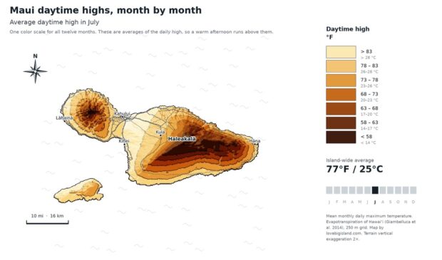
Maui Weather by Month: Which Side to Stay On
Kīhei gets rain on 36 days a year, Hāna on 267. How Maui weather works month by month, what a rain percentage really means, and which coast to pick.
Weather summary for Kīhei
Of the three Maui towns we chart, Kīhei is the driest at 11.5 inches a year, ahead of Lāhainā at 13.3 and far ahead of Hāna at 67.7. It is also the least cloudy at 39% against Lāhainā’s 40% and Hāna’s 64%, and the warmest, 74.9°F to Lāhainā’s 74.85. Between Kīhei and Lāhainā the weather is a near tie; pick between them on location and lodging, not climate. For prices and crowds month by month, see the best time to visit Maui.
| month | Temperature (°F) | Rainfall (in) | Cloud Frequency (%) |
|---|---|---|---|
| January | 71.25 | 2.765 | 36.49 |
| February | 71.21 | 1.646 | 37.46 |
| March | 72.00 | 1.019 | 43.24 |
| April | 73.42 | 0.477 | 47.01 |
| May | 75.09 | 0.568 | 44.84 |
| June | 76.77 | 0.224 | 43.08 |
| July | 77.74 | 0.124 | 37.17 |
| August | 78.43 | 0.146 | 35.74 |
| September | 77.86 | 0.232 | 33.90 |
| October | 77.55 | 0.319 | 38.16 |
| November | 75.00 | 1.479 | 37.72 |
| December | 72.53 | 2.463 | 33.91 |
| Annual | 74.90 | 11.462 | 39.06 |
Monthly average Kīhei weather: temperature, rainfall and cloud cover
Monthly average temperatures in Kīhei run from 71°F (22°C) in February to 78°F (26°C) in August, with September just behind.
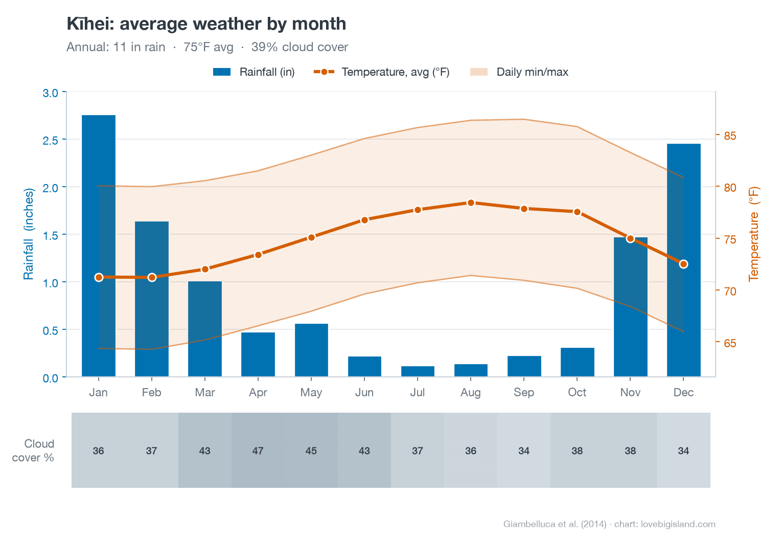
Those are whole-day averages. The average daily high runs 80 to 86°F and the average daily low 64 to 71°F, a swing of about 15 degrees between afternoon and the small hours. Even in February, the coolest month, the average low is 64°F.
January is the wettest month at 2.8 inches and July the driest at 0.12, and less rain falls across the six months from May through October than in January alone. Cloud cover averages 39% across the year, cloudiest in April at 47%, with September and December the clearest months, both near 34%.
How often it rains in Kīhei
Rain reaches Kīhei on 36 days in an average year, and rain tops an inch on only 4 of them. June has zero days of measurable rain, and 0.07 inches across the whole month.
If you’re picking dates around rain, nearly all of it sits in winter. 18 of the year’s 36 wet days fall from January through March, and 3 from June through September. 78.9% of the annual rainfall falls between November and March.
When a dry place does get rain, it usually comes in a few big storms. On February 23, 1951 the gauge caught 6.75 inches in a single day, more than half the 12.84-inch annual average over the same 1949-2012 record.
Hourly average Kīhei weather: air temperature and cloud cover
Cloud cover sits near 31% overnight, dips to its daily low near 25% around 8am, then builds through the late morning to a peak near 60% around 2pm before thinning again toward sunset.
The sky over Kīhei is more than twice as cloudy at 2pm as at 8am, so take the morning slot for a snorkel trip or a beach day and save errands and shade time for the early afternoon.
Mornings are calm, and the onshore sea breeze makes the early afternoon the windiest part of the day. At Kahului, the nearest station with a wind record, the wind roughly doubles from a dawn lull to a mid-afternoon peak near 20 mph.
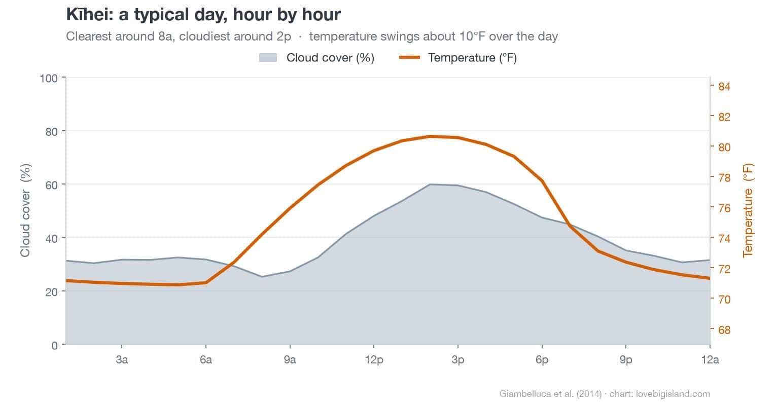
Air temperature follows a flatter curve, from about 71°F just before dawn to 81°F in the early afternoon. That is the hourly average across all days, so it sits inside the wider daily high and low above.
Kīhei weather forecast
Everything on this page is a long-term average. Any given day in Kīhei can differ widely from these numbers.
For the seven-day outlook, check the NOAA point forecast for Kīhei.
Kīhei sits in two forecast zones
The National Weather Service splits Kīhei between two forecast zones, and the line runs through the middle of town. The northern end, including the long-running town rain gauge, sits in HIZ046, Maui Central Valley South. Central and south Kīhei, and Wailea beyond them, sit in HIZ049, South Maui / Upcountry.
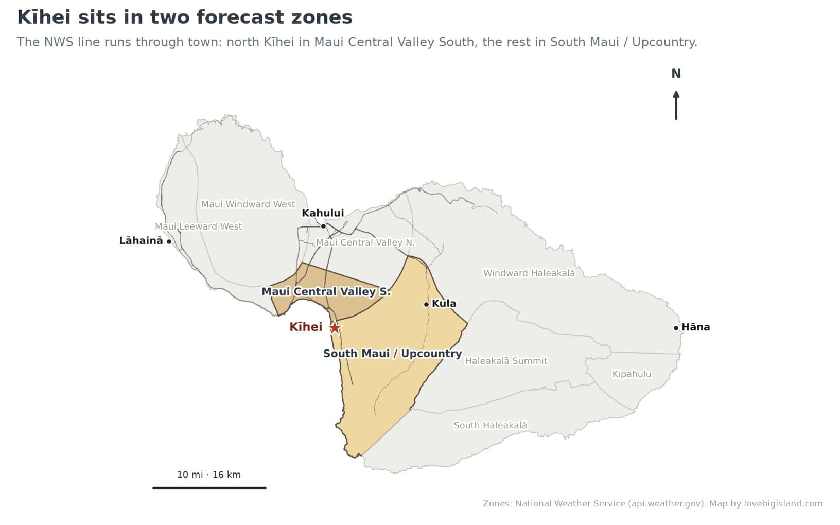
Kīhei straddles two National Weather Service forecast zones: north Kīhei in Maui Central Valley South (HIZ046), the rest in South Maui / Upcountry (HIZ049). Zones: National Weather Service. Map by Love Big Island.
HIZ049 runs from the Kīhei shoreline all the way up Haleakalā to 4,000 feet, so a single forecast for it has to span about 13 or 14 degrees, warm at the beach and cool upcountry. At sea level in Kīhei you want the warm end of that range. Most weather apps and local forecast sites skip the split and give Kīhei a single south-shore number, so it only matters if you read the NWS zone forecast directly.
Sources and methods
- Monthly and hourly temperature, rainfall and cloud: Kīhei’s own point in the University of Hawaiʻi 250-metre atlas grid, from Giambelluca et al. (2014), Evapotranspiration of Hawaiʻi, via the Rainfall Atlas of Hawaiʻi. The 11.5-inch annual figure is a gridded estimate, which interpolates between gauges.
- Rain-day counts and the single-day records: Western Regional Climate Center period-of-record summary for the Kīhei gauge, 1949–2012, and the Kahului comparison from NOAA 1991–2020 normals.
- Wind: nearest measured station, Kahului Airport (no free Kīhei wind record exists).
- Forecast zones: National Weather Service public forecast zones (api.weather.gov).
- The rule that dry areas get their rain in a few big storms: the Hawaiʻi climate chapter Saul Price wrote for the 1983 Atlas of Hawaiʻi.
- Explore the data yourself: the UH Hawaiʻi Climate Data Portal publishes interactive climate maps, live readings from the Hawaiʻi Mesonet station network (live data), and monthly climate summaries.