
On September 26, 2013, USGS measured what was left of Lake Waiau at 114 square meters, about 1,200 square feet, and nowhere more than 8 inches deep. The same bed has held 5,000 to 7,000 square meters over the past 200 years. Waiau is the only alpine lake in Hawaiʻi, sitting at 13,020 ft (3,969 m) in a cinder cone below the Maunakea summit.
Gerrit walked down to it in 2018 and found it full again. Waiau is a wahi pana, a sacred place, and swimming in it is prohibited. Getting there means driving above the Visitor Information Station at 9,200 ft, where 2WD vehicles are not permitted.
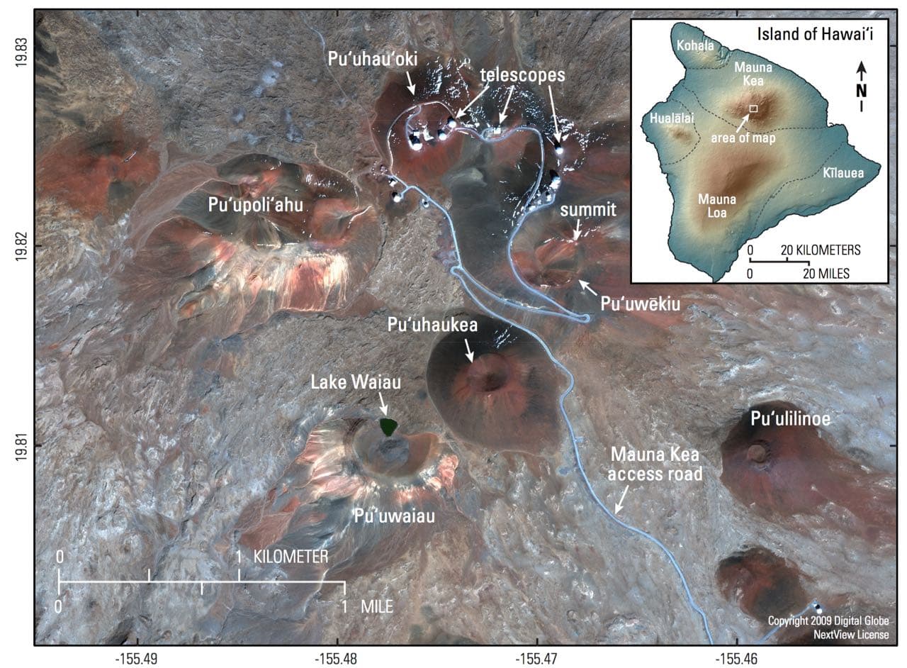
Satellite view of the Maunakea summit area on November 23, 2009, taken by GeoEye-1. Lake Waiau is the small green patch inside Puʻu Waiau, southwest of the telescopes, and the true summit stands on Puʻuwēkiu. The inset locates the area on the Island of Hawaiʻi. Image credit: USGS
Why Lake Waiau holds water
Hawaiian volcanoes don’t usually hold water. The basins that could are floored either with permeable lava flows or with cinder and ash, so rain and snowmelt drain straight through. Under Lake Waiau a layer of fine-grained ash and clay slows the seepage, and it took researchers decades to settle that.
Researchers proposed three explanations:
- Sulfur-bearing steam from Maunakea altered the local cinders and ash into fine clay minerals, cutting the permeability of the soil enough to hold water.
- Glaciers once covered the summit of Maunakea. Eruptions beneath glacial ice produce fine-grained ash beds, and those beds could still be slowing seepage out of the small crater today.
- Permafrost was found near the summit in late 1969, reaching at least 10 m (33 ft) down, and was long proposed as the impervious layer under the lake.
A 2016 geophysical survey ruled the permafrost out. Leopold, Morelli and Schörghofer measured ground temperatures too high and electrical resistivity too low for buried ice, and pointed instead at fine-grained ash and the clay it weathers into. The permafrost that does exist on Maunakea is under Puʻuwēkiu, the true summit cone. USGS reports none under Puʻu Waiau.
USGS rejected a related claim in 2003, that Waiau is a tropical lake fed by melting permafrost. It’s an alpine lake in the tropics, and no permafrost feeds it. Read the USGS Volcano Watch column for the competing explanations.
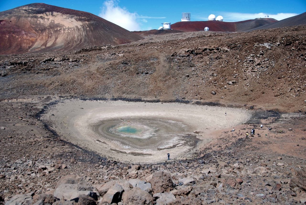
What was left of Lake Waiau on September 26, 2013: 114 square meters of water in a dry bed about 100 meters (109 yards) across. The telescopes on the skyline stand at the Maunakea summit. Photo credit: USGS
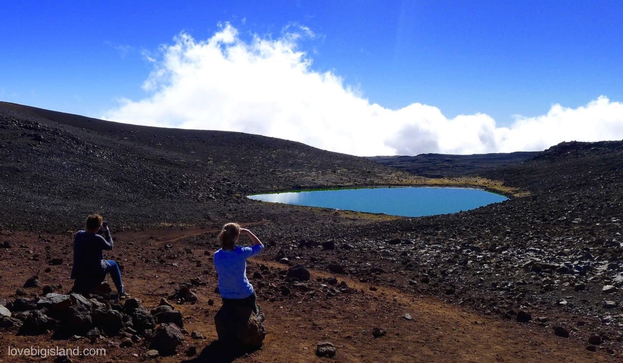
Lake Waiau in July 2016, with water across the crater floor. The lake lies in the crater of Puʻu Waiau at 13,020 ft (3,969 m).
Lake Waiau’s 2009 to 2014 shrinkage and recovery
The lake shrank for four straight years, then came back. The published record of what happened stops in 2014.
Two satellite images date the start of the decline: 6,193 square meters on December 24, 2009, already down to 4,175 by September 29, 2010. It kept falling. On September 26, 2013, USGS measured 114 square meters, with abandoned sediment-coring pipes standing clear of the water. Rain in early 2014 refilled it, and by April 4 the lake covered 3,419 square meters.
Patrick and Kauahikaua tie the collapse to the severe drought that ran across the Hawaiian Islands from roughly 2008 to 2014, when rainfall stopped keeping up with evaporation and seepage through the lake bed. The water level on any visit depends on the rain in the months before.
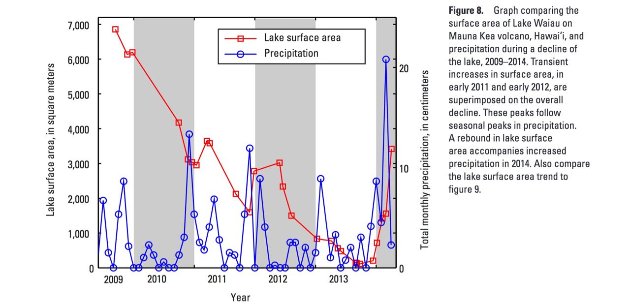
Lake Waiau’s surface area in red against total monthly precipitation in blue, 2009 to 2014. Figure 8 of USGS Scientific Investigations Report 2015-5076, by Matthew R. Patrick and James Kauahikaua.
USGS last visited on June 20, 2014, and reported the lake back near its pre-2010 size, though still under its usual range. Gerrit found a full lake on his own visit in 2018, and Hawaiʻi DLNR staff have told West Hawaii Today that it has been full or nearly full since late 2014, but the state’s monitoring data has never been published.
Lake Waiau in the Hawaiian Cultural Tradition
Waiau means swirling water of a current. It is also the name of a snow goddess in Hawaiian tradition. The summit is the piko, the umbilical cord joining the earth to the sky, and one of the most sacred places in the islands.
In Hawaiian tradition the lake’s water carries healing, and families have placed the piko of newborn children in it to give them long life. In 1882, while she was competing to become ruling chief of the Hawaiian kingdom, Queen Emma Kaleleonālani climbed to the summit and bathed in the lake.
Approach the mountain as a wahi pana, a storied place: ask permission of the ancestors before you go up, then give thanks. That is the Center for Maunakea Stewardship’s protocol. Quiet chant or prayer is the appropriate hoʻokupu (offering). Physical offerings can damage a site. Don’t leave food; it carries ants and non-native seeds up the mountain, and DLNR bans it for that reason.
Read the translated story of Pele and the snow goddess for more on Waiau in Hawaiian mythology.
Visiting Lake Waiau
The Maunakea Access Road leaves the Daniel K. Inouye Highway at milepost 28 and climbs to the Visitor Information Station at 9,200 ft. Above the station only 4WD is allowed, and the eight miles to the top rise nearly 5,000 ft on single-lane unpaved sections. Plan on at least 30 minutes at the station to acclimatize before going higher.
Don’t go above the Visitor Information Station if you are under 13, pregnant, have heart, blood pressure or respiratory conditions, or have been scuba diving in the past 24 hours. That is the University of Hawaiʻi’s rule.
Check the rental car before you count on driving up. The University of Hawaiʻi tells drivers to verify the summit road with their rental company. Two local outfits, Big Island Jeep Rental and Hawaii Lifted Jeep Rentals, rent vehicles specifically for it. There is no fuel above the station either, and the nearest pumps are about 35 miles away in Hilo, Waimea or Waikoloa Village.
The walk to the lake starts from a pullout on the summit road above the 6-mile marker, near Puʻu Haukea, and drops into the crater of Puʻu Waiau. The Big Island Hikes write-up puts it at 1.2 miles round trip with 375 ft of gain. Every step of the return is above 13,000 ft. Stay on the designated trail, and fill in the registration form at the Visitor Information Station before setting out.
The lake lies inside the Mauna Kea Ice Age Natural Area Reserve, 3,894 acres set aside in 1981, and no permit is needed to walk in on your own. Signs at the trailhead identify Waiau as a sacred site and prohibit swimming, watercraft and rock piling. Drones are not allowed on Maunakea lands. The summit area closes half an hour after sunset, so start back up from the lake with daylight to spare. Our stargazing guide describes the same drive after dark.
Lake Waiau Interesting Facts
- Lake Waiau lies in the crater of Puʻu Waiau, inside the Mauna Kea Ice Age Natural Area Reserve, at 13,020 ft (3,969 m). It’s the only alpine lake in the Hawaiian island chain, and USGS calls it one of the highest lakes in the United States. [source]
- Over the past 200 years its surface area has usually run between 5,000 and 7,000 square meters. The plunge that began between 2009 and 2010 followed the drought recorded on the Big Island from 2008. [research]
- The seal that keeps water in the lake is most likely fine-grained ash and the clay it weathers into. A 2016 geophysical survey ruled out the permafrost explanation. [background]
- The same 2016 survey found a second body of water in the Puʻupōhaku cinder cone at about 4,000 m (13,100 ft), and a third pond appeared briefly on glacial till at 3,594 m (11,790 ft) after Hurricane Lane in August 2018. [research]