
The east side of every Hawaiian island gets far more rain than the west, often in the same week. Temperature barely enters into it: sea-level daytime highs run from the high 70s to the high 80s in every month of the year, and the ocean holds them there. Rain is the one variable worth planning around, and on any island the first question is which coast you sleep on.
The season shifts how much rain falls, not where it falls. Winter is the wetter half of the year, summer the drier. This page covers the patterns that hold across all the islands. For the month-by-month numbers on one island, use the island guides at the bottom.
Table of contents
- About Hawaiian weather: how does being an island shape the weather?
- The two Hawaiian seasons (winter and summer)
- Every island has a wet side and a dry side
- Hurricane season
- The best time to visit Hawaiʻi
- Weather by island
The influence of Hawaiʻi’s location on its weather
Few places on earth sit as far from anywhere as Hawaiʻi. The nearest mainland coast is about 2,300 miles away, Tokyo about 4,050 miles, and Sydney about 5,100. There is a lot of ocean between Hawaiʻi and everywhere else.
Because of its proximity to the equator, temperatures are mild and the length of the day is fairly constant through the year. The dominant winds come from the east and northeast (the trade winds, explained below). And because of all that ocean and the high volcanoes, rainfall can change dramatically over short distances, while severe storms stay rare.
The two Hawaiian seasons: winter (rainy) and summer (dry)
The Hawaiian Islands have two main seasons: good and better.
Just kidding. We call the two seasons summer and winter and skip spring and autumn. Summer is the dry season, winter the rainy season. The main difference between them is rainfall, with more rain falling in the winter months.
Temperatures across the year
Temperatures are mild and steady. NOAA’s 1991-2020 normals put summer daytime highs in the mid-80s Fahrenheit on the sunny leeward coasts and a couple of degrees cooler on the wetter windward coasts, with winter taking about three degrees off both. No lowland station averages 90°F in any month of the year.
Elevation moves the number far more than the calendar does. The drive from a warm coast up to 2,700 feet drops the annual average from about 75°F to 65°F, and the highest summits, on the Big Island and Maui, sit below freezing on winter nights. The ocean is what holds the coast steady: water temperatures around the islands run from about 76°F (24°C) in late winter to about 81°F (27°C) in early autumn, and that narrow range holds coastal air temperatures just as steady.
For month-by-month temperature on a single island, see the island guides at the bottom of this page.
Rainfall in winter and summer
The wettest months fall between November and March, but winter rain rarely wrecks a trip. Weather here is intensely local, so when it is raining where you stand you can usually find a dry spot nearby. The wet-and-dry pattern barely moves through the year. What changes is how much falls: winter storms are heavier, and summer can drop to half the winter rate.
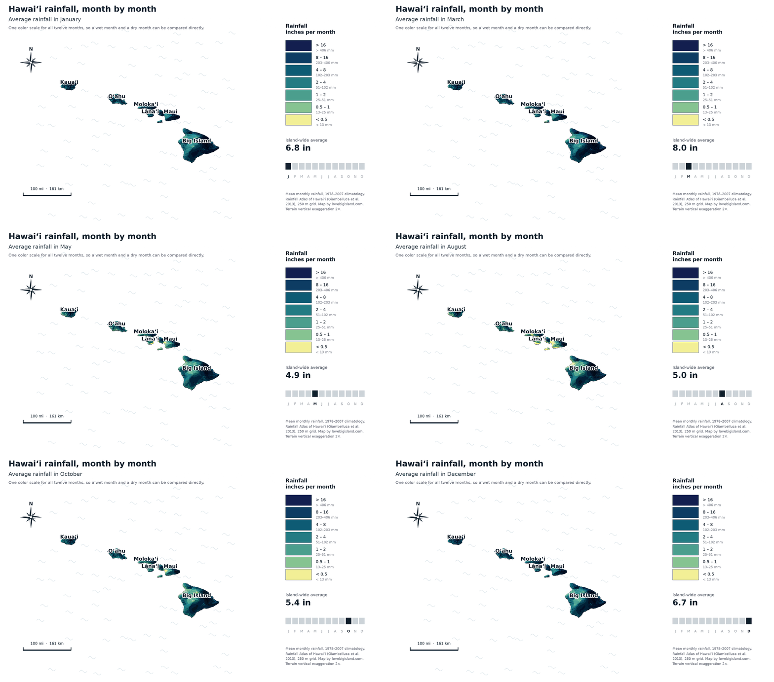
Average monthly rainfall across the islands, all twelve months on one fixed scale. Data: Rainfall Atlas of Hawaiʻi (Giambelluca et al. 2013), 250 m grid. Map by Love Big Island.
Each island guide below maps its rainfall month by month, in more detail than a single statewide map can show.
Every island has a wet side and a dry side: the trade winds
Weather across Hawaiʻi is driven by the trade winds. They blow out of high-pressure zones in the north Pacific, pushing cool, moist air onto the islands’ eastern and northeastern slopes. They earned the name because their steady, predictable pattern carried trade ships across the Pacific as early as the 16th century.
The trades blow most of the year: 80 to 95 percent of the time from May through September, easing to 50 to 80 percent from October through April (Climatography of the United States, NOAA and the Western Regional Climate Center).
When the trades hit an island’s mountains the air is forced upward, and as it rises the moisture condenses into cloud and rain. In weather terms the side the wind comes from is the upwind or windward side, and it stays wet; the far, downwind side is the leeward side, and it stays dry. Every main Hawaiian island works this way: windward coasts stay wet, leeward coasts stay dry.
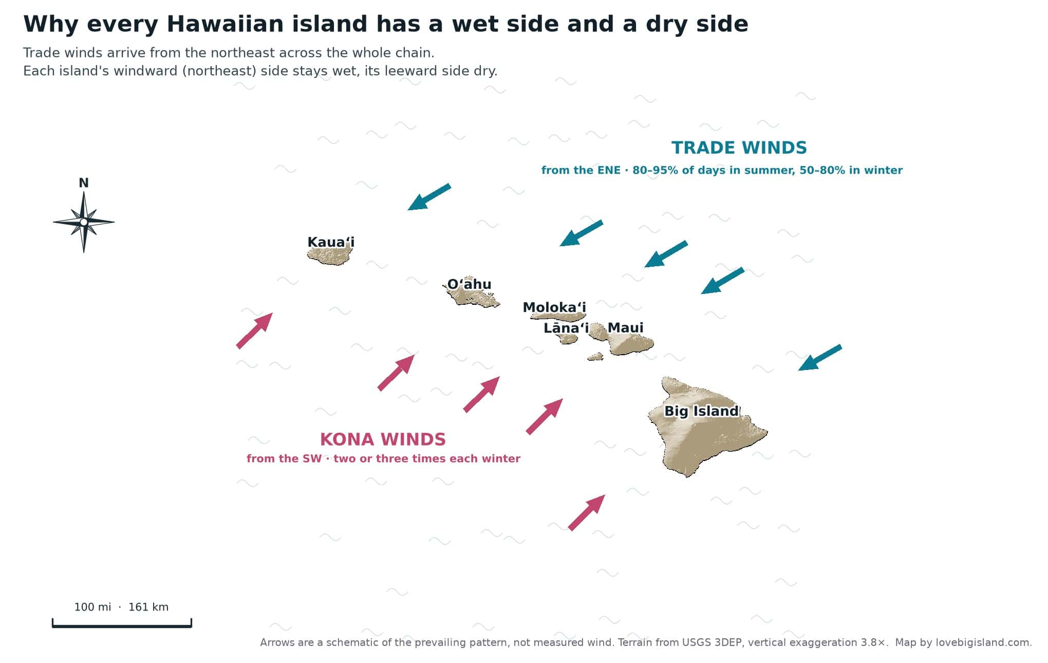
How trade winds and kona winds reach the islands. Terrain: USGS 3DEP. Map by Love Big Island.
The exception is the Kona wind, which arrives from the southwest a handful of times a year and reverses the pattern, wetting the usually dry leeward coasts. It is named from kona, the Hawaiian word for the leeward, southwest side of an island: the direction the wind blows from. The Big Island’s Kona coast carries the same name for the same reason.
The same split drives the climate zones on each island: humid tropical on the windward side, arid on the leeward side. Read more about the climate zones on the Big Island, Maui, Kauaʻi, and Oʻahu.
Hurricane season in Hawaiʻi
Most storms that reach Hawaiʻi bring heavy rain and big surf and little else. The season runs June through November, with most activity between July and September.
A hurricane is the strongest class of tropical cyclone: sustained winds of at least 74 mph (64 knots), force 12 on the Beaufort scale. The same storm is called a typhoon or a cyclone in other parts of the world.
Part of the reason the islands get off lightly is their high volcanoes, which act as a natural buffer. Their peaks disrupt the wind circulation and help break up and weaken a storm as it moves toward and over land.
So what does a hurricane mean for you, the visitor?
Mostly bad weather and a lot of rain.
Depending on how close the storm is and how strong the winds are, a tropical storm or hurricane watch may be issued for one or more of the islands. When that happens, local shops and national parks can close for a day or a few. In the most extreme cases, flights are delayed or rescheduled.
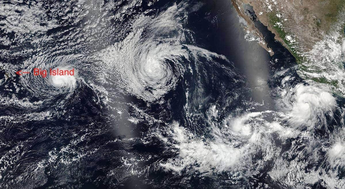
Four simultaneous tropical cyclones heading for Hawaii on July 22, 2016. From left to right: Darby, Estelle, Eight-E (which would soon become Georgette), and Frank. By National Oceanic and Atmospheric Administration, VIIRS, captured on SNPP satellite, source, Public Domain, Link
For more on the storms that have reached the Hawaiian islands since the 1950s, see Hurricanes in Hawaii from the University of Hawaiʻi.
While you are here, watches and warnings for Hawaiian waters come from the NOAA Central Pacific Hurricane Center. Tropical Tidbits carries worldwide storm info.
What is the best time to visit Hawaiʻi?
There is no single best time to visit Hawaiʻi. Temperatures are good all year, so timing comes down to rain and daylight. The islands are busiest from mid-June through August and from mid-December through mid-March, and prices climb then, but the weather does not follow the crowds.
Best time to visit: the driest months
Temperatures stay constant and pleasant through the year, but rainfall does vary. The driest months run May through October, the occasional hurricane aside.
If you are trying to escape winter on the mainland, come during the cold months back home.
Best time to visit: most daylight
The length of the day also shifts through the year. Days in June are about 2.5 hours longer than those in December. If you are planning an active trip, more daylight adds real hours to your visit.
Best time to visit: for the different islands
If you already know which island(s) you want to visit, let that guide your timing. See our island-specific guides:
- The best time to visit the Big Island
- The best time to visit Maui
- The best time to visit Kauaʻi
- The best time to visit Oʻahu
Weather by island
Once you know which island you are on, the island guide has the month-by-month numbers, the local wet and dry coasts, and the town-level detail.