
For its size, Hawaiʻi records more earthquakes than any other state. The islands shake, and often: by raw count Hawaiʻi ranks third, behind Alaska and California, but it is far smaller than either, so no state has more quakes per square mile. Nearly every one traces back to the islands’ own volcanoes.
If you are heading to the Big Island and wondering whether the shaking should worry you, it should not: almost all quakes here are too small to feel, and damaging ones are rare. The strongest in decades was the magnitude 6.9 that struck on May 4, 2018, during the Kīlauea eruption. We live on the island, and most weeks the only quakes we notice show up on the USGS feed, and we never feel them.
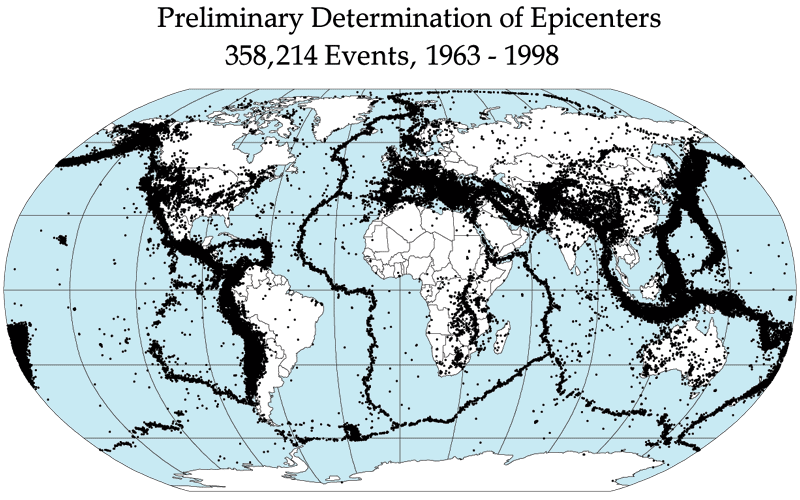
Preliminary Determination of Epicenters of all 358,214 events recorded between 1963 and 1998. Image credit: NASA. Each black dot is one earthquake epicenter. Hawaiʻi, on the far left, is almost solid black.
Hawaiʻi has more earthquakes per square mile than any other state
By raw count, Alaska leads every state, with more than half of the country’s earthquakes on its own and California a distant second. Hawaiʻi comes third, at roughly 7 percent of the national total.
By earthquakes per square mile, Hawaiʻi leads every state. Hawaiʻi is by far the smallest of the seismically active states, so once you divide each state’s earthquake count by its land area, nothing else comes close. The table ranks the ten states with the most earthquakes and adds that per-area figure.
| State | Earthquakes 1974–2003 | Land area sq. miles | Percent of US total | Density (per 10,000 sq mi) | |
|---|---|---|---|---|---|
| 1 | Alaska | 12,053 | 570,641 | 57.2% | 211 |
| 2 | California | 4,895 | 155,779 | 23.2% | 314 |
| 3 | Hawaiʻi | 1,533 | 6,423 | 7.3% | 2,387 |
| 4 | Nevada | 778 | 109,781 | 3.7% | 71 |
| 5 | Washington | 424 | 66,456 | 2.0% | 64 |
| 6 | Idaho | 404 | 82,643 | 1.9% | 49 |
| 7 | Wyoming | 217 | 97,093 | 1.0% | 22 |
| 8 | Montana | 186 | 145,546 | 0.9% | 13 |
| 9 | Utah | 139 | 82,170 | 0.7% | 17 |
| 10 | Oregon | 73 | 95,988 | 0.3% | 8 |
How to read this: the count column is the USGS tally of magnitude 3.5 and larger earthquakes from 1974 through 2003, the most recent multi-decade state ranking the agency has published, so it reflects long-term patterns rather than the last few years.
The percent column is each state’s share of the 21,080 US earthquakes in that window, and these ten states account for about 98 percent of them. The density column is ours, not the USGS’s: we divided each state’s count by its land area (US Census) and scaled it to earthquakes per 10,000 square miles, so states of very different sizes can be compared on equal footing. The USGS ranks states by raw count only and publishes no per-area ranking.
Hawaiʻi records about seven times as many earthquakes per square mile as California, and more than ten times as many as Alaska, all from one of the smallest states in the country.
Where Hawaiʻi’s earthquakes come from
Every earthquake is a sudden release of energy in the earth’s crust. Most are caused by movement along faults, but volcanic activity, landslides, and even human activity can trigger them too.
Hawaiʻi sits far from any fault line, out in the middle of the Pacific plate, which is part of what makes its volcanoes so unusual. What shakes the islands instead is the volcanic hotspot beneath them. Magma forcing its way up through the crust, and the sheer weight of the volcanoes pressing down on it, keep the ground under near-constant stress. So almost every Hawaiʻi earthquake traces back to the volcanoes.
The animation below plays every recorded earthquake worldwide in sequence from January 1, 2001, through December 31, 2015.
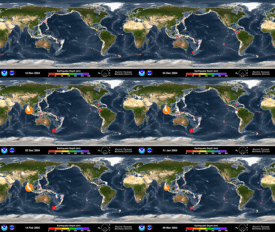
This animation plays every recorded earthquake in sequence as it occurred from January 1, 2001, through December 31, 2015. Credit: the US NWS Pacific Tsunami Warning Center (PTWC)
Most Hawaiʻi earthquakes happen around Kīlauea
The Big Island is the youngest and most volcanically active island, so it has the most earthquakes by far. Most cluster around Kīlauea, its summit and rift zones, where magma sits closest to the surface. Maui also has an active volcano, but it is far quieter.
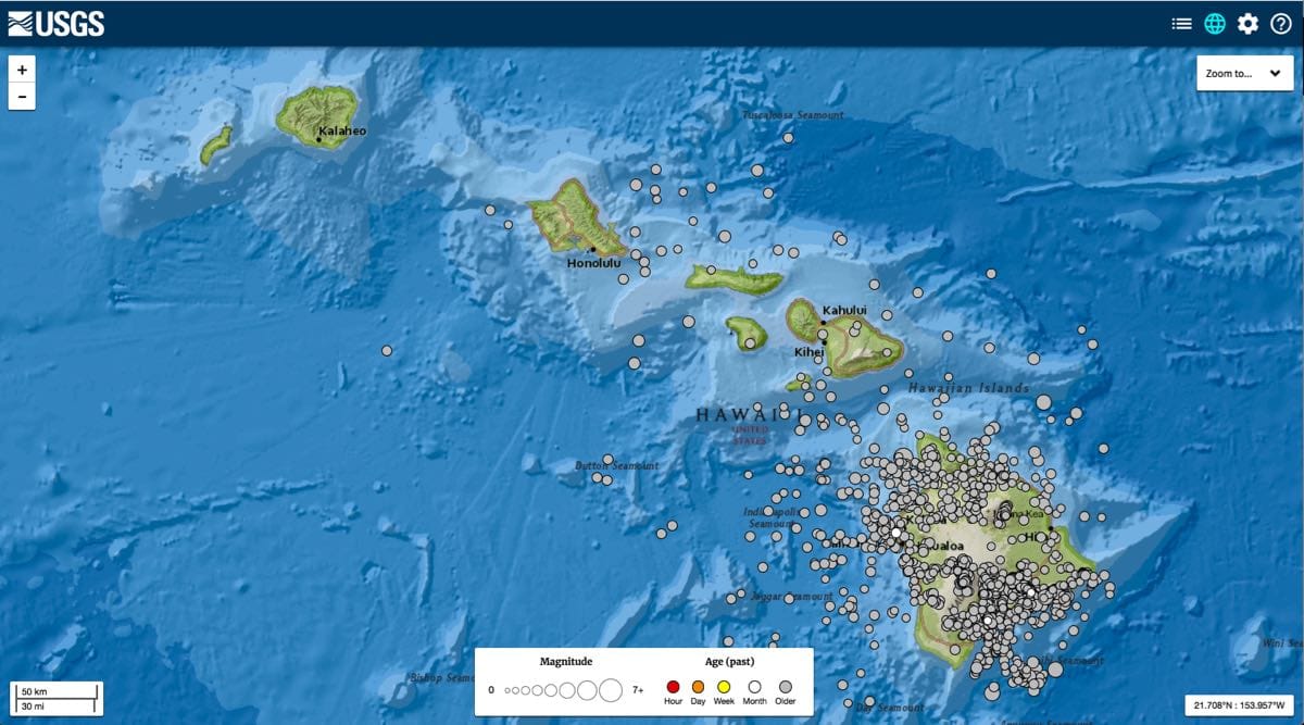
Seismic map of Hawaiʻi showing all 1,766 earthquakes larger than magnitude 2.5 between 2000 and 2018. Created using the USGS earthquake catalog
How dangerous Hawaiʻi earthquakes are
Most Hawaiʻi earthquakes are tiny adjustments in the crust that you’ll never feel. If you think you felt one and want to check, the USGS earthquake map shows every recent quake with its location and magnitude.
Big ones do strike, though. The strongest in recent memory was a magnitude 6.9 on May 4, 2018, in lower Puna during the Kīlauea eruption, the largest in Hawaiʻi since 1975. The most recent quake of magnitude 6 or greater before that was a 6.2 near Nāʻālehu in 2021. The last Hawaiʻi earthquake to kill anyone was the 1975 Kalapana quake, which took two lives (the USGS now lists it at moment magnitude 7.7, long cited as 7.2). The largest in recorded history hit the Kaʻū district in 1868, an estimated magnitude 7.9 that claimed 77 lives.
Most of those deaths came from landslides and tsunamis, not the shaking itself. In the 1868 quake, landslides killed 31 people and the tsunami another 46.
What to do if you feel one
For almost every quake, nothing: it’s over in seconds. The exception is strong or long shaking near the coast. Treat that as a natural tsunami warning and move to higher ground right away, without waiting for a siren or an official alert, because a tsunami set off close to the islands can arrive within minutes.
The state runs an outdoor siren network for ocean hazards, and you’ll hear it tested from time to time. Anywhere else, the standard advice holds: drop, cover, and hold on until the shaking stops.
Tsunamis and Hawaiʻi
Tsunamis can be triggered by both earthquakes and landslides. When part of an island breaks away and slides into the ocean, it can throw up an enormous wave.: when part of an island breaks away and slides into the ocean, it can throw up an enormous wave. It doesn’t happen often. Marine deposits sit at least 1,600 feet up the slopes of Lānaʻi, left by a giant wave around 120,000 years ago. [source]
In this BBC Nature segment, Gary McMurtry of the University of Hawaiʻi walks through how Hawaiian mega-tsunamis form:

Where these numbers come from
We kept the math simple. We counted every earthquake of magnitude 3.5 or larger equally, so a 3.5 carries the same weight as a 7.9, even though you’d feel the two very differently and from very different distances.
We also counted quakes strictly by state line, which slightly undercounts a state sitting next to an active neighbor. And the density figure is our own: the USGS publishes the raw counts, and we divided them by land area to compare states of very different sizes on equal terms.