Puna is where the Big Island is still being built. The 2018 eruption on Kīlauea’s East Rift Zone buried more than 13 square miles in lava and pushed 875 acres of new land into the sea, and the black sand beaches at Kaimū and Pohoiki are still forming as the coastline reshapes itself. This is the windward district, east of Hilo, the most off-the-grid corner of the island and the one that changes the fastest.
Come here for the raw version of Hawaiʻi, not the resort one. There is almost no resort infrastructure, which is the point. Pāhoa town, the Red Road that hugs the undeveloped coast, the Sunday farmers market at Makuʻu with its 150-plus vendors, and Wednesday nights at Uncle Robert’s in Kalapana all sit within a short drive of each other. Start with where the 2018 flow crossed the road.
Table of contents
Puna covers just under 500 square miles (320,000 acres), only slightly smaller than the island of Kauaʻi, and borders South Hilo to the north and Kaʻū to the west. The volcanic activity that makes it dangerous also makes it fertile: this is some of the best farmland in the state, thick with nurseries and farms growing tropical flowers, papayas, and bananas.
Before we start with our guide, a request: Please tread lightly while visiting this part of the world. The people of Puna are a happy, welcoming, and resilient bunch, but the communities here are still recovering from the events of 2018 and no one likes to feel like the recipient of disaster tourism. Drive with aloha, pay attention to signage and directions from well-meaning locals and remember to slow down, smile and enjoy your time here.
How recent history shaped Puna
Puna stays raw and undeveloped for one reason: it sits on the East Rift Zone of Kīlauea, one of the most active volcanoes on Earth. Lava can arrive here with little warning, which is exactly why so little permanent infrastructure ever takes hold.
Puna is an ever-changing and exceptionally risky place to call home, and the high-risk/high-payoff of living here attracts a hardy crowd that has shaped the face of this frontier for decades. The result is an eclectic and colorful collection of homes and businesses, scattered through this vast expanse, that reflect the face of the brave populace willing to risk everything for a chance to live in one of the wildest regions in the state.
Puna captured the imaginations of spectators across the globe in 2018 when, on May 3, a fissure opened, and lava started spewing out onto a residential street in the Leilani Estates subdivision. By June, hundreds of homes in several subdivisions had been destroyed. Lasting just over 3 months, the eruption concluded in early August, at which time over 13 square miles of existing land had been covered by lava, and over 875 acres of new land was created offshore. This episode would come to be known as the 2018 LERZ eruption and its drastic effects on the region and local populace can still be seen.
Our 9 Favorite Places to See in Puna
You could spend days working through the back roads and hidden corners of Puna, but most visitors have an afternoon or a day to give it. These are the nine stops we would prioritize:
- Pāhoa
- The Painted Church
- Kalapana
- Kaimū and Uncle Robert’s
- The Red Road
- Mackenzie State Park
- Pohoiki (Isaac Hale)
- Lava Tree Monument
- Makuʻu Farmers’ Market
Pāhoa
Tucked into the eastern corner of the Big Island and in the heart of the Puna district is the colorful little town of Pāhoa. In your haste to venture on into lower Puna and the areas affected by the 2018 LERZ you might think to simply pass right through, but you’d be far better served to spend some time here wandering through the quirky collection of shops, museums and galleries that line the main street, or to stop for coffee or a meal in one of its numerous cafes and eateries.
Secluded by acres of rain forest and lava flows, Pāhoa is unlike any other place you’ll find in Hawaiʻi and will begin to prepare you for your journey into one of the most mystical and constantly changing areas in the state.
The town came dangerously close to being devoured by lava in a 2014 eruption that started and stalled several times over the period of a few weeks, finally halting just a few miles north of the main road. The Royal Gardens subdivision and the villages of Kaimu and Kalapana were largely destroyed by earlier flows. In 2018 the intense glow of the LERZ eruption in Leilani Estates, just 5 miles to the north, could be seen from the main road of Pāhoa.
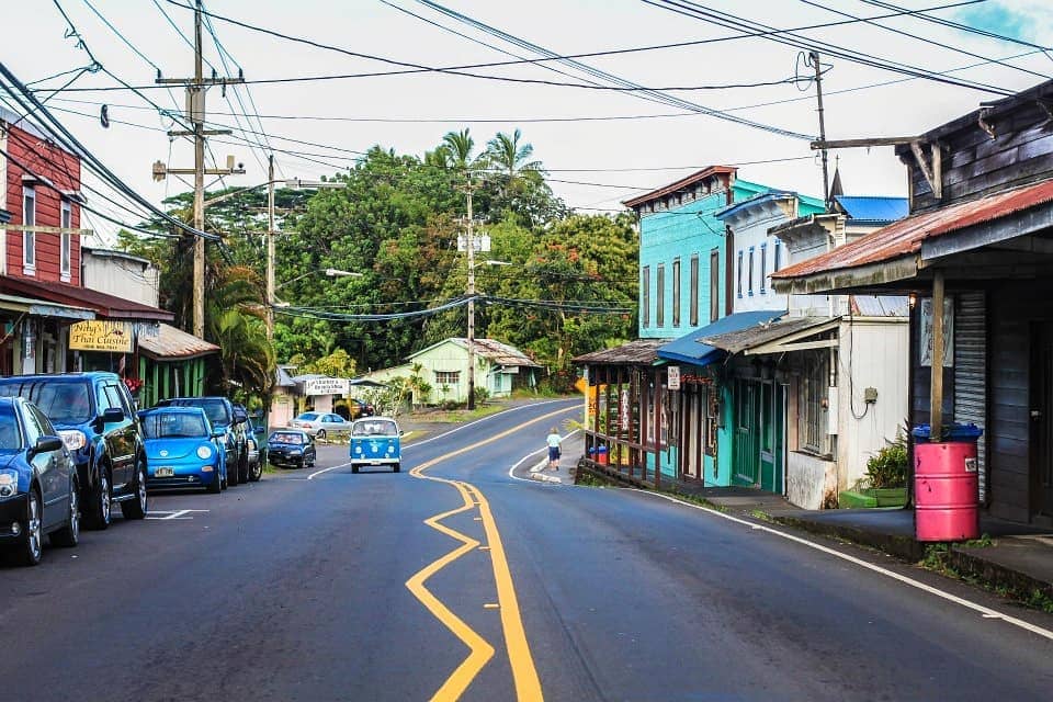
Downtown Pahoa with its raised wooden sidewalk, the false-front stores and the numerous old buildings, has a certain “Wild West” atmosphere. Image Credit: Joey Gutierrez.
The Painted Church
At the end of the main street in Pāhoa, you can continue south about 10 mins on Highway 130 to the Star of the Sea Painted Church (colloquially just the Painted Church).
Built in 1928 under the direction of the Belgian Catholic missionary priest Father Evarist Gielen, the church was dramatically moved from its original location in the village of Kalapana, ahead of an advancing lava flow in 1990 that would go on to decimate the entirety of the once-beloved village.
By no means an architectural wonder, the Painted Church is a serene, modest spot that offers a strong example of Hawaiian folk art. A quick stop here will certainly give you more appreciation for the scope of the devastation that lies ahead on our journey.
Good to know: there is another painted church in the south Kona district, called the St Benedict Catholic Church.
Kalapana
The village of Kalapana was once one of the most picturesque spots in the Hawaiian Islands. Oozing with old-Hawaii charm, an off the beaten track feel and a healthy collection of local resident artists, it attracted many visitors to the shores of its famous Kamoamoa Beach and ancient Hawaiian Queen’s Baths.
In 1990, lava flows from the Kūpaʻianahā vent on the southeast rift zone of Kīlauea destroyed and partly buried most of the town, as well as the nearby Kalapana Gardens and Royal Gardens subdivisions, and the town and bay of Kaimū which now lie under more than 50 feet of lava. It was the most devastating flow to a residential area in the islands until the 2018 LERZ flow in Leilani Estates.
Today it is possible to drive out to the site of the old town and gaze over the vast lava fields stretching up the slopes of Kīlauea toward Puʻu ʻŌʻō. Many of the previous homeowners have rebuilt on the lava fields and the sight of the odd structure juxtaposed against the stark blackness of this veritable finisterre is eerie and humbling.
Pop trivia: Kamoamoa Beach was the shooting location for the video clip of Chris Isaak’s iconic song Wicked Game in 1989. The beach would go on to be completely engulfed by lava less than a year later.
Kaimū and Uncle Robert’s
Backtracking a bit will bring you to the turnoff for Kaimū the small neighboring town that was destroyed by the eruption in 1990. In Hawaiian, kai mū means “gathering [at the] sea” to watch surfing.
Today you can enjoy the short walk from the parking area to a new black sand beach being formed in Kaimū Bay. The sound of the waves grinding lava into pristine black sand is unique and the sight of the infant beach is a stark reminder of the constant change and re-creation in this part of the world.
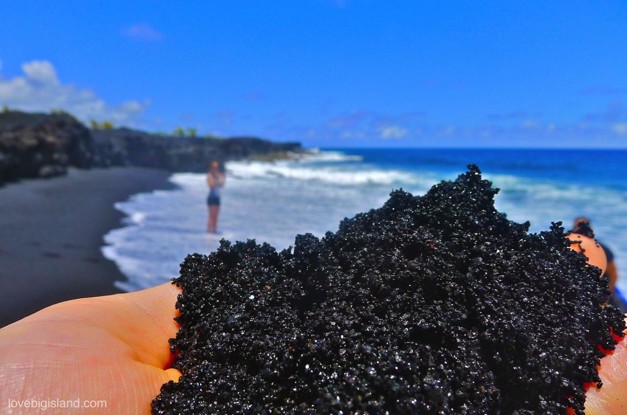
If you look closely you can see that the black sand at the beach consists out of fragments of solidified lava.
After a visit to the beach, you should stop by for a look around Uncle Robert’s, a hodge-podge collection of vendors, eateries and a kava bar open Saturday morning and Wednesday evening (5pm- 9pm). The latter time is when things really get going here and the stalls and tables fill up with visitors and locals alike, enjoying the live music, tasty food, and the warm, festive ambiance.
The Red Road
The Kapoho-Kalapana Road, also known as the Red Road, is one of the most remote and scenic drives on the island. It winds north from Kaimū along rugged, exposed coastline, through lush coconut groves and tropical rainforests. The road was covered by lava at several points by the 2018 LERZ eruption and journeying along it now is a good way to get a scope of the destruction this event caused.
Take time to stop at the many scenic points and small beaches along the way while enjoying the slow pace of life in this part of the world.
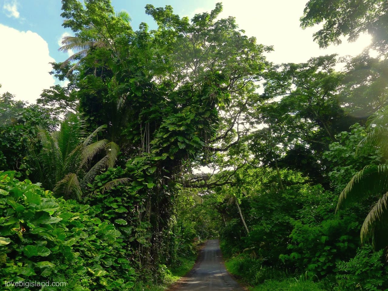
The Kalapana – Kapoho road (also known as red road) is one of the most scenic drives on the Big Island
Mackenzie State Park
Spooky and wind-battered, MacKenzie State Park is a 13-acre recreation area perched on the jagged lava sea cliffs along the Red Road. The signature feature of the park is the largest stand of ironwood trees in the Hawaiian Islands and the main attraction is experiencing the raw power of the waves along the sea cliffs.
There are restrooms and a covered picnic pavilion. Camping is not advised, and rogue waves are extremely dangerous so please heed the numerous danger signs. Park entrance is free but entry into lava tubes or caves is prohibited.
Pohoiki (Isaac Hale Beach Park)
For decades, the boat ramp and surf break at Pohoiki Bay were an iconic spot in the Puna area. Over the summer of 2018 locals and visitors alike watched with trepidation as the lava crept closer to the bay and threatened to engulf the area. When the eruption subsided, strong currents swept tons of newly formed sand from down the coast into the bay, dumping immense amounts of new black sand on the existing beach and closing off the harbor and warm water lagoon from the ocean.
A short walk from the water will take you to the edges of the 2018 lava flow. Eerie and wondrous, Pohoiki balck sand beach is a sight to behold. Swimming is not advised.
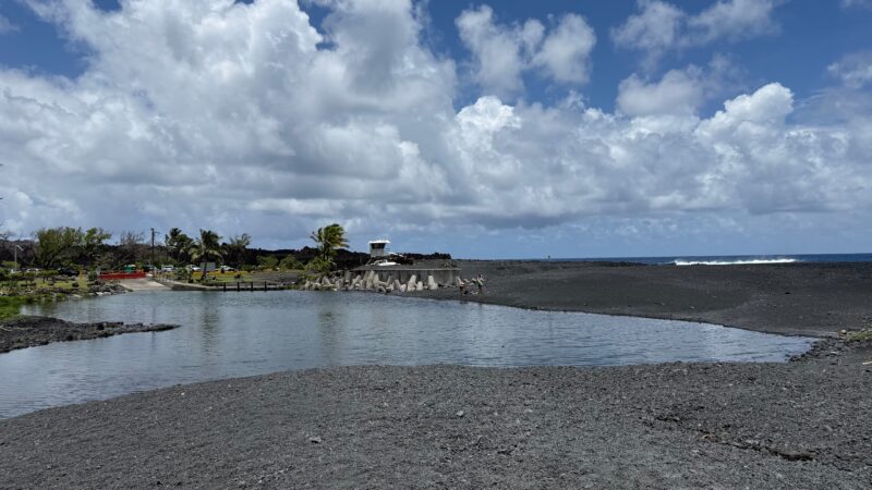
Looking back from the black sand at Isaac Hale Beach Park: the lifeguard tower, the warm ocean thermal pond near the boat ramp, and the parking area are all visible. The solidified lava along the coastline marks the edge of the 2018 Kīlauea flow that created this beach.
Lava Tree Monument
Off of the Pahoa-Pohoiki Road, and just outside of Pāhoa Town is the strange and fascinating Lava Trees State Park. Here you can take the 0.7-mile loop trail in this 17-acre State Monument to view the unusual lava molds of tree trunks, created when a lava flow swept through the area in the 1790s, coating the trunks of indigenous ohia trees and leaving tall lava molds in its wake.
An easy and accessible walk, this is a fine way to see the work of Pele (the goddess of fire) in what amounts to an open-air sculpture garden. Restrooms, clean water, and picnic tables on-site.
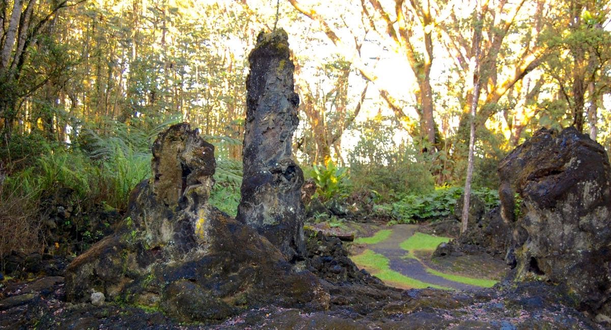
Lava trees, such as these ones on the Lava Tree State Park, are the result of a lava flow that swept through this forested area and left behind lava molds of the tree. By Sean A. Clevenger [CC BY-SA 3.0], from Wikimedia Commons
Makuʻu Farmers’ Market
The Makuʻu Farmers’ Market is a sprawling open-air market just outside Pāhoa town. With now over 173 vendors, it offers an eclectic mix of international foods, most made with locally sourced ingredients.
Beyond the food stalls, you can find fresh and often organic produce from local farms nearby, homegrown or homemade products such as Puna goat cheese, local lehua honey, coffee, vanilla, macadamia nuts, chocolate, jams and pickled or baked goods. Vendors also sell handmade soaps, jewelry, and clothing, as well as crafts, pottery, books, and so much more.
A hot spot for live music and other entertainment, it is common for local residents to drop in with their whole families on Sundays to shop, explore, graze and socialize.
Note: The Makuʻu Farmers’ Market (website) runs every Sunday from 7:30 AM to 2 PM. No pets or animals are allowed at the market, except for service dogs.
Where to Eat
Pāhoa is the only town in Puna with a real cluster of places to eat, so plan to stop here whether you want a quick snack or a sit-down meal. All five are on or near the main street.
- Kaleo’s: Innovative Hawaiian-style Asian-American dishes served in a funky, relaxed space with live music.
- Ning’s: Small, charming restaurant on the main street of Pāhoa, offering fresh and authentic Thai cuisine in an airy setting.
- Luquin’s: This laid-back spot dishes up generous portions of tacos, burritos, nachos & other Mexican fare.
- Pele’s Kitchen: Farm-To-Table breakfast spot featuring fresh local fruits, garden-fresh veggies, and local coffee.
- Island Natural Market and Deli: A good spot if you prefer to grab something to enjoy at the beach. Great selection of organic and locally sourced salads, sandwiches, sushi and hot dishes from the buffet.
Practicalities
Puna is the least developed district on the island, and a few things are worth planning around before you go: the weather, the wildlife, and how to see the 2018 eruption zone respectfully.
- Weather
- Little Fire Ants
- Culture and off-limits areas
- Respectfully seeing the 2018 LERZ eruption aftermath
1: Weather
The area of lower Puna ranges from sea level to the 650ft. (200m) elevation line in Pāhoa. Temperatures here are warm all year-round, alternating showers and sunshine are common, and humidity levels can easily reach 90%. Make sure to bring layer-able clothing and stay hydrated. Extra sunscreen and insect repellent also come in handy when venturing into the forested areas near the ocean.
2: Little Fire Ants (LFA)
The one genuine nuisance in Puna is the little fire ant (Wasmannia auropunctata). The species is tiny, but the sting packs a punch out of proportion to its size: an intense, quickly spreading burn.
Take care when touching or brushing against trees and other vegetation. If you are unlucky enough to be attacked by little fire ants, stay calm and brush as many of them off you as possible. Use a cool, damp towel to sooth the skin and remove any of the ants you may have missed. If swelling, itching, or burning persists for more than a few hours afterward, an over the counter hydrocortisone cream can be applied sparingly.
Little fire ants are easily transported on cars, shoes, plant materials, and produce, so also take extra care when coming and going from the area, as you may unwittingly take them along for the ride.
3: Culture and Off-limits Areas
You may have heard about Leilani Estates, ground zero of the 2018 LERZ eruption and home to Fissure 8. Leilani Estates is still a residential neighborhood and all roads except for Leilani Avenue are private. You cannot park along Leilani Avenue and the people living here do not appreciate what they perceive as disaster tourism.
Please show consideration for the residents and avoid this neighborhood altogether. You can see enough of the area while following Highway 130 to the South from Pāhoa, for example at Lava Tree State Monument.
4: Respectfully seeing the aftermath of the 2018 LERZ eruption
The 2018 Lower East Rift Zone (LERZ) eruption zone is the most sobering thing you can see in Puna, and one of the most affecting on the whole island: a firsthand look at the impact of an eruption on the local people and ecology.
Starting in Pāhoa you can stop in for a look at the Pahoa Lava Zone Museum. This is a small building featuring artifacts from the last eruption, photographs taken by locals, and exhibits from the now-abandoned Jaggar museum.
From Pāhoa, follow Highway 132 to the South/East. This road was rebuilt over the still-cooling lava flows that covered it in 2018 and it provides some of the best impressions. You can follow this road up to a point that used to be called “4 Corners”, but now is only one corner and the end of the road. From here you can see a panorama of miles of new lava rock.
Following Hwy 130 further South brings you deeper into an area that was largely spared by the 2018 eruption, offering a glimpse into what the greater parts of the wild Puna area were like before this and the many other eruptions that have shaped this part of the island. This is one of our favorite scenic drives on the island!