The island of Hawaii with its many different ecosystems and low population density is made for hikes and there are enough trails to keep you entertained for months. Our five favorite hikes on the Big Island are a good guide for when you don’t have enough time on our island to ‘see it all’.
Like most visitors you probably only have time for one or two short hikes during your stay on the Big Island. This is why we have put together this list with five short hikes which we consider the “low hanging fruits”. Each hike on this list shows a different highlight of Hawaii and takes between ~1 hour up to half a day:
Table of contents
- Kilauea Iki Trail hike: 4 miles round trip, difficulty: medium
- Waipi’o Valley hike: (currently closed) 6.5 miles round trip, difficulty: medium
- Pololu Valley hike: 2.5 miles round trip, difficulty: easy
- Hawaii Bioreserve & Gardens: 1.5 miles, difficulty: easy
- Mauna Loa Lookout: variable, at least 1.5 miles, difficulty: easy
Table of Contents
- Kilauea Iki Trail hike: 4 miles round trip, difficulty: medium
- Waipi’o Valley hike: (currently closed) 6.5 miles round trip, difficulty: medium
- Pololu Valley hike: 2.5 miles round trip, difficulty: easy
- Hawaii Bioreserve & Gardens: 1.5 miles, difficulty: easy
- Mauna Loa Lookout: variable, at least 1.5 miles, difficulty: easy
Related guides: Most people coming to Hawaiʻi visit multiple islands to make the most of the long trip needed to get here. If this is you and you are into hiking, we highly recommend our hiking series for the other islands.
Kīlauea Iki Trail#
(4 miles round trip, difficulty: medium, Hawaii Volcanoes National Park)
This is the hike we recommend the most if you only have time for one hike during your visit to Hawaii!

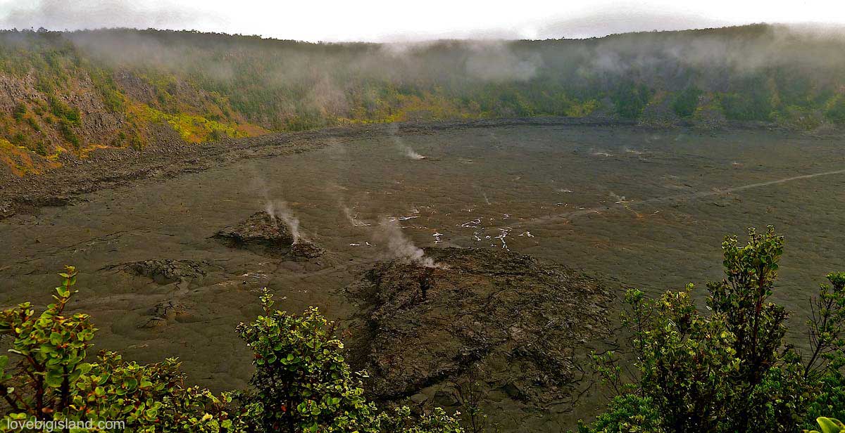
Overview of the Kīlauea Iki caldera, This caldera hosts one of the most spectacular (and moderately easy) hikes on the island
Summary: the Kīlauea Iki trail will lead you through a lush ohia forest down into the Kīlauea Iki crater, straight over the crater floor past warm and steaming fissures in the ground. The crater floor was formed almost 60 years ago (in 1959, more about the Kīlauea Iki crater eruption), and the small ohia shrubs are only now starting to grow in the cracks of the solidified lava.
Directions: The Kīlauea Iki trail is located inside the Hawaii Volcanoes National Park at the Kīlauea Iki overlook parking lot.
The hike: Looking towards the crater pick up the trail turning rights following the trail, which slowly descends into the crater through a lush rainforest. Once you reach the crater look down to the ground every now and then. In and between the cinders you can find the little green crystals (olivines) that are also responsible for the green color of the sand at Papakolea beach. On the far side of the crater the trail goes up again. After a steep climb you pass the Thurston Lava Tube (well worth a 30 minute detour). You can find a more elaborate trail guide for this hike at the national park website.
We rate this hike as moderately difficult even though it is relatively short because you have to climb in and out of the crater. This means there are two relatively short stretches during which you have to cover 400 vertical feet up and down. We recommend that you start on this hike early (8 a.m.) to beat the heat and the crowds. Starting early also lets you hear the birds when they are most active and gives you the best photo opportunities.
Tip to avoid crowds: Park at Devastation and embark on a six-mile (9.7 km) round-trip hike into, up, and around Kīlauea Iki from Uēaloha (Byron Ledge). The scenery includes panoramic views of Kīlauea caldera, Mauna Loa (on clear days), and native forest with tall tree ferns.
About the Kīlauea Iki eruption: At November 14, 1959, a spectacular eruption began and flooded the crater with 68 million tons of lava, creating a lava lake several hundred feet deep, and a dramatic fountain that ejected lava 1,900 feet (580 meters) into the sky. The eruption ended five weeks after it started, and the surface of the lava lake solidified. Today, you can hike over that solidified lava lake on what hikers consider to be one of the finest trails in the park.
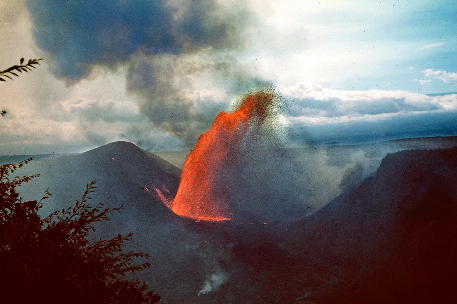
At the height of the eruption a lava fountain reached 1,900 feet (580 meters) into the sky. Credit: 1959 USGS photo.
Waipiʻo Valley #
(6.5 miles round trip, difficulty: medium, Kohala)
Waipio Valley road is closed
Waipiʻo Valley Road is closed to visitors and access to the valley floor and the subsequent valleys is not possible anymore. The Waipiʻo Lookout is still accessible. Read more details in our dedicated Waipiʻo valley guide.
Summary: this hike will take you down 800 ft into the ‘Valley of Kings’. Waipiʻo valley can be described as a lush, tropical, fairy tale valley with many waterfalls and a black sand surfers beach. Make sure to take plenty of water, some food and a trash bag to pack out everything you take in. (read more about Waipiʻo Valley)
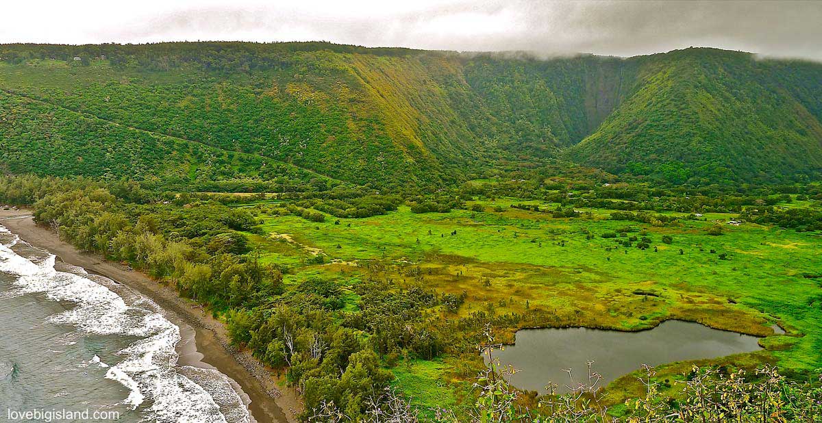
Overview of Waipiʻo Valley from the ‘opposite’ side. You can see the steep access road, the black sand beach, and taro fields.
Directions: Follow Hwy 240 to the end (coming from Honoka’a) park your car at the parking. A short stroll takes you to the Waipio Valley Lookout where you can read about the royal and disastrous history of the valley (a Tsunami in 1946 wiped almost the whole valley clean) and take some postcard perfect pictures of Waipi’o Valley.
The hike: This is where the ‘fun’ starts. You will have to hike down the Waipiʻo Valley access road. This road gains 800 vertical feet in only 0.6 miles, and has a 25% average grade! It is only accessible to 4WD cars (and rightly so, losing control over your car on this road would mean certain dead, as witnessed from the many overgrown car wrecks on the cliff!). Take it slow on this road, you are not in a hurry and the payoff will be amazing!
On the bottom of the road, turn right to reach Waipiʻo Beach after a short (10 min) hike. This fine grain black sand beach is popular with surfers. If you want to take a dip to cool down please go ahead, but watch out for the strong currents – don’t let the water get higher than your hips.
If you continue to the right on the coast, you will reach the Kuluahine falls. Hug the shore to reach the bottom of these falls. From here, double back to the Waipiʻo Valley access road. If you have spare time on your hands, consider to also turn left (coming from the lookout) on the bottom of the valley, you will find taro fields, and probably will spot some wild horses. You can also see the 1400 feet high Hiʻilawe on the far left of the valley from here. Take care to stay on the road and not to trespass on private property.
Local grinds: On your way to Waipi’o valley, stop at Tex Drive Inn for a good breakfast or their specialty: Portuguese Malasadas (deep fried donuts).
Pololu Valley#
(2.5 miles round trip, difficulty: easy, Kohala)
Summary: Pololu valley is one of the most scenic valleys of the state! Don’t forget to take your camera and comfortable hiking boots (tennis shoes will do on a dry day), and plenty of water.
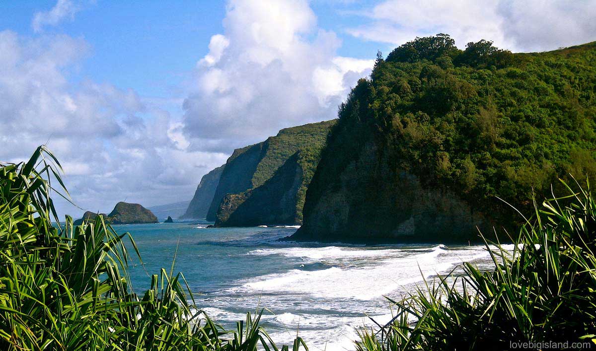
View of the Pololu black sand beach and the dramatic cliffs in the direction of Waipi’o valley
Directions: The Pololu Valley lookout is at the end of the Akoni Pule Hwy (270), East of the quaint town of Hawi on the Northern tip of the Big Island. Depending on how busy it is you may have to park your car along the road and walk a few minutes.
The hike: the steep but short hike takes you down a lush tropical cliff to a rugged black sand beach. The trip down can be made leisurely in 30-45 minutes one way, and we recommend to take a picnic basket along to enjoy while sitting one the rugged beach after a refreshing dip. (read more about picnic areas in Hawaiʻi)
Local grinds: Stop in Hawi for the best ice cream and fudge across from the Bamboo restaurant, or try out the Motek bakery for delicious pastries.
Hawaii Tropical Bioreserve & Gardens#
(1.5 miles, difficulty: easy, HTBG website, close to Hilo)
Summary: the Hawaii Tropical Bioreserve & Gardens are out favorite botanical gardens on the Big Island. Here, you can see over 2000 different species of plants and trees and a visit here is a must-do for everyone with green fingers!
Directions: To get to the gardens turn Ma Kai (towards the ocean) between mile marker 7 and 8 on Hwy 19 coming from Hilo, onto the scenic drive in the direction of Onomea Bay. Continue for 1.75 miles to reach garden entrance.
The hike: there is no real hiking needed here, more a slow meandering around the gardens for a few hours. The self-guided tour is just over one mile long (round trip) and takes about 1.5 to 2 hours. If you would want to go on a longer hike you can take the 2.5 miles (round trip) donkey trail down to Onomea Bay and Turtle Cove whose trailhead is just outside the gardens.
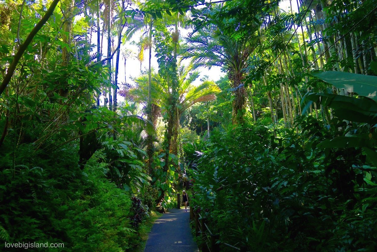
The 1 mile self-guided tour in the Hawaii Tropical Bioreserve & Gardens is one of our favorite short hikes on the Big Island
As an added extra, to get to these gardens you have to take one of the most scenic drives of the Big Island!
Admission to the gardens: Take note, admission to the gardens is not free. The fee for one day is $30 for adults, children ages 6 – 12 are $22 (kamaʻaina rates are $22 for adults and $15 for keiki). Children under 6 are free (2023 rates). The gardens are opened daily between 9 am and 5 pm, but the latest admission is at 4 pm.
You receive a trail guide when you purchase your ticket to the gardens. Try not to miss the bird aviary and the seascapes at the lower end of the gardens. Take some time to sit down and take in the sights, smells, and sounds at different places to get immersed in this peaceful place.
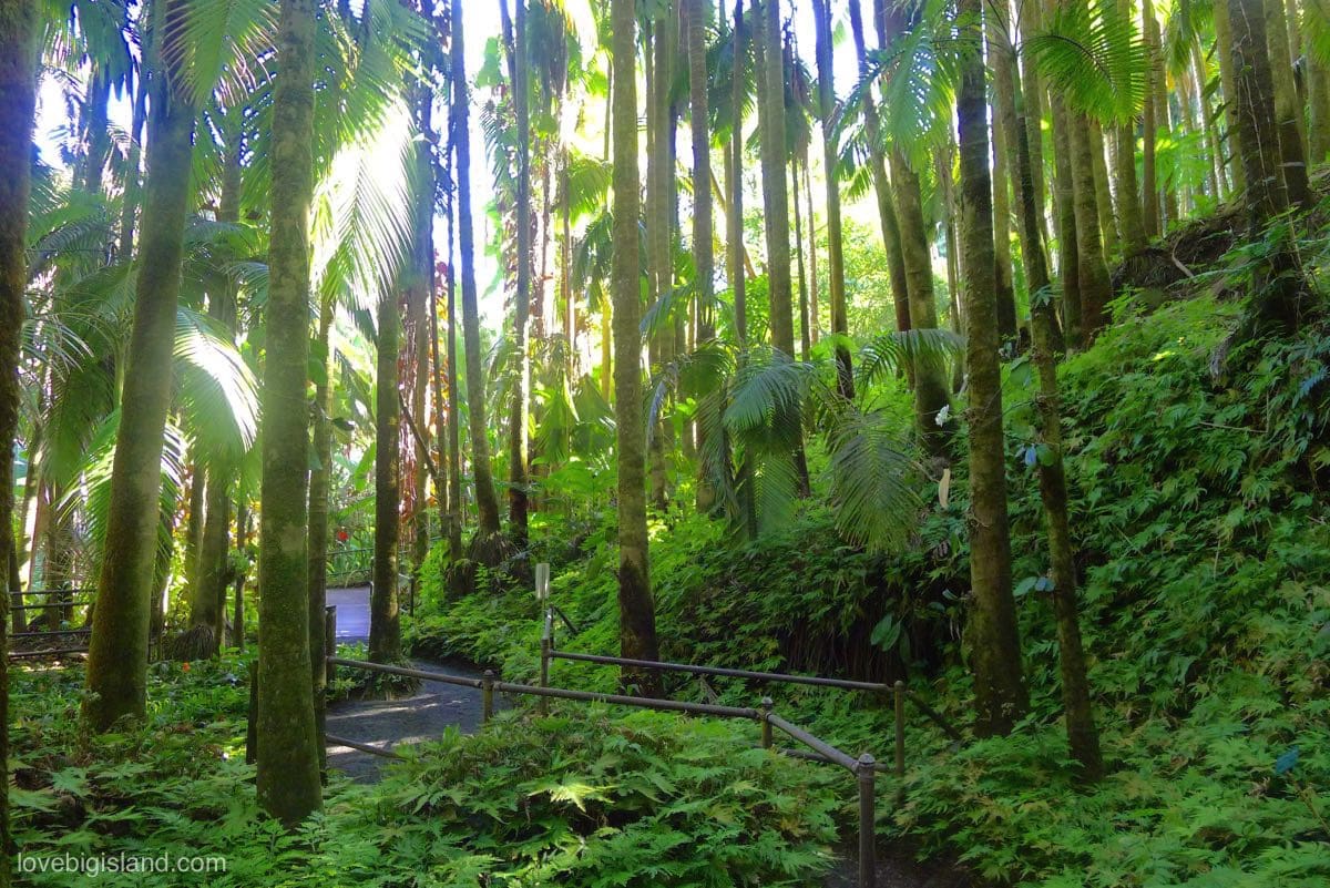
The lush Hawaii Tropical Bioreserve & Gardens are our favorite place on the Big Island to admire the plants and flowers from the rainforest
Have a look at the following video if you are interested in an impression of the gardens. Did we already tell you that it’s smart to take an umbrella? The gardens are in the rainforest after all :)

This is by far our favorite botanical garden on the island. If you want to see more however, have a look at our complete list of botanical gardens on the Big Island.
If you don’t feel like organizing a visit yourself you can always visit this garden as part of an organized tour, such as this day-long photo tour also visiting Waipiʻo Valley and several waterfalls.
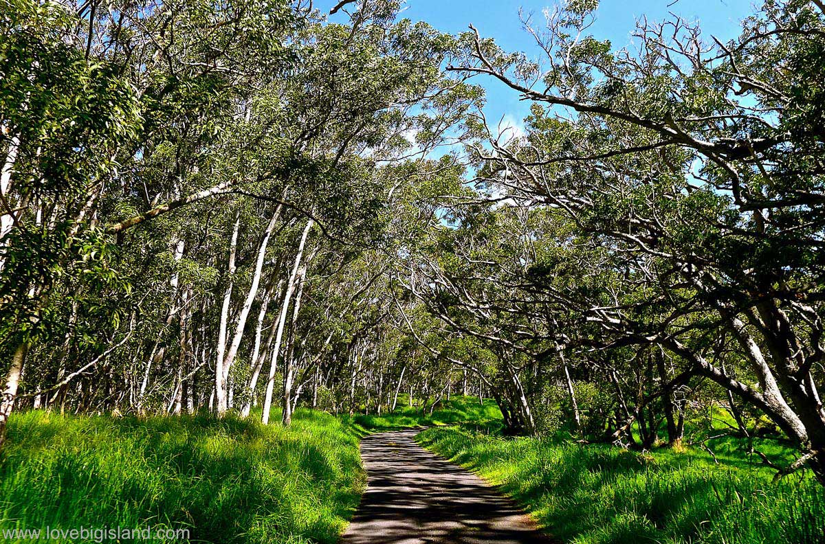
Mauna Loa Lookout#
(variable, at least 1.5 miles, difficulty: easy, Volcano Village)
Summary: the road to this hike is at least half the fun (and is one of our 5 favorite scenic drives on the Big Island)! It leads you up the slopes of Mauna Loa and as you leave the Kilauea Crater behind you, you pass through a bird park, green koa forests, old lava flows and plenty of places where you can stop your car and take in the surroundings! This hike, however, is at its best when the sun is out. When the sky is overcast, choose the Kīlauea Iki trail instead.
The Mauna Loa access road is an 11-mile scenic road climbing Mauna Loa up to over 6000 ft.
Directions: from Volcano Village, take Hwy 11 in the direction of Kona, and turn Ma Uka (towards the mountain) between mile marker 31 and 32 onto Mauna Loa Rd. After 1.5 miles you will reach a turnaround and the trailhead for the 1 mile Kipuka Puaulu (bird park) trail. On the far side of the turnaround you will find an open gate. Continue through this gate onto the Mauna Loa Scenic Strip. The road winds up the slope for 10 miles to an elevation of 6662 feet. Do take your time on this Scenic strip and look back to the Kilauea Crater often for dramatic views!
On the end of the road you find a little kiosk which is the trail head for the Mauna Loa Trail, also nicknamed the ‘Trail of Tears’. From this point it is still an 18-mile hike to the summit of Mauna Loa, so forget about reaching the summit.
The hike: you will only need to follow the Mauna Loa Trail for a short distance to see the rugged beauty of Mauna Loa. Follow the trail up the mountain over smooth red lava until you reach the black aʻa lava of the Keamoku flow. The trail will take you more directly up the mountain from here, and the trail will become less distinct and signed by rock cairns. Somewhere here is a nice point to turn around. Keep looking back on your way up to make sure you know how to walk back.
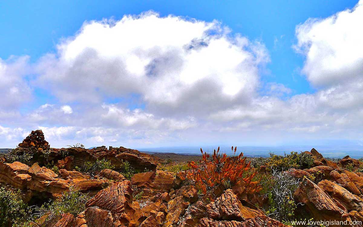
This will be your view back to the ocean after a 35-minute hike up the Mauna Loa trail.